LMKR Founded in 1994, LMKR is a petroleum technology company with an extensive solutions portfolio that includes reservoir centric interpretation, modeling and analytics software, mobile technology solutions, E&P data services as well as geoscience and information management consulting solutions all focused towards lowering the risk associated with exploration and production of conventional and unconventional resource plays.
I received a lot of strikes from Schlumberger untill schlumberger software become available on many sites.
now I receive strikes from other people who sell these software on internet, and this topic my reply, and in next time you will see Schlumberger Softwares (IOGeophysicist).NZB because peers not seeding, I need depend on servers.
Size 15 GB & you can make uncheck for any software that not want to Download it.
First
you must setup "Schlumberger Licensing 2013.exe" not make it If you
want setup petrel 2011 (32bit) after I do it only petrel2013 work well.
IP is a fast, flexible and robust software package that can be used by many disciplines including petrophysicists, geologists and reservoir engineers.The software allows you to maximise the potential from well data by offering control and flexibility through a user-friendly and intuitive interface.
Individual modules or grouped bundles based around common disciplines can be purchased to create bespoke packages for users.
What's new in IP 4.2:
Senergy Software is pleased to announce the release of the
latest version of our powerful petrophysics analysis tool. IP™ 4.2
features a number of new modules as well as many additional enhancements
and functionality improvements.
After Downloading and to watch those videos better.
(Right click > video frame > stretch to window) to appear as this.
How to Install IP:
1) Install IP_v4.2.exe 2) Copy all files in "Patched" folder to "C:\Program Files\IntPetro42". 3) Copy register file "Reg" to "C:\Program Files\IntPetro42". 4) Open "Reg.reg" yes --> ok. 5) Run the program.
MATLAB is a high-level language and interactive environment for numerical computation, visualization, and programming. Using MATLAB, you can analyze data, develop algorithms, and create models and applications. The language, tools, and built-in math functions enable you to explore multiple approaches and reach a solution faster than with spreadsheets or traditional programming languages, such as C/C++ or Java™.
You can use MATLAB for a range of applications, including signal processing and communications, image and video processing, control systems, test and measurement, computational finance, and computational biology. More than a million engineers and scientists in industry and academia use MATLAB, the language of technical computing.
MathWorks today announced Release 2014a (R2014a) of its MATLAB and Simulink product families. R2014a includes new releases of MATLAB and Simulink, and updates and bug fixes to 81 other products.
MATLAB uses
الرياضيات و الحساب Math and computation
تطوير الخوارزميات Algorithm development
معالجة وجلب البيانات Data acquisition
النمذجة والمحاكاة Modeling, simulation, and prototyping
تحليل واستكشاف وتصوير البيانات Data analysis, exploration, and visualization
الرسوم الهندسية والبيانية Scientific and engineering graphics
بناء واجهات استخدام رسومية للتطبيقات المعدة Application development, including graphical user interface building.
Aquaveo Surface Water Modeling System v10.1.8+Crack
SMS is developed by Aquaveo, an engineering services company with many years of experience developing groundwater modeling solutions.
Aquaveo pioneered the conceptual model approach. Build a conceptual model in SMS by constructing a high level representation of the model using familiar GIS objects: points, arcs and polygons.
Work with large, complex models in a simple and efficient manner by using the conceptual modeling approach and easily update or change the model as needed.
3D visualization optimized for performance
Interact with models in true 3D.
Optimized OpenGL graphics for improved hardware rendering.
Create photo-realistic renderings.
Generate animations for PowerPoint or web presentations.
Drape images over the model and control the opacity.
Annotations – Add north arrows, scale bars, reference images, company logos, and more.
Advanced riverine & coastal modeling
SMS interfaces with a wide range of numerical models for applications including:
Riverine analysis.
Contaminate transport.
Sediment transport.
Particle tracking.
Rural & urban flooding.
Estuarine.
Coastal circulation.
Inlet & wave modeling.
Import what you need
Models require data from many different sources. That’s why SMS is built to easily import numerous file types:
Raster images including georeference and projection support.
Topographical maps & aerial photos.
Elevation & bathymetry data.
Web data services such as TerraServer.
ArcGIS geodatabases and shapefiles.
CAD files including .dwg, .dgn, and .dxf formats.
Worldwide projection support including Cartesian and Geographic Systems.
File Import wizard for delimited text files and spreadsheets.
How Install Surface Water Modeling System v10.1.8
1- Setup the Program. 2- Copy all files in "Crack" folder to "C:\Program Files (x86)\SMS 10.1". 3- Run the Program from Desktop. 4- Enjoy.
Data acquisition is the foundation of the seismic lifecycle. It is critical that accurate decisions are made as part of the acquisition design process.
In order to meet these challenges, companies require flexible and robust survey design tools that provide accurate analysis to effectively image their subsurface targets.
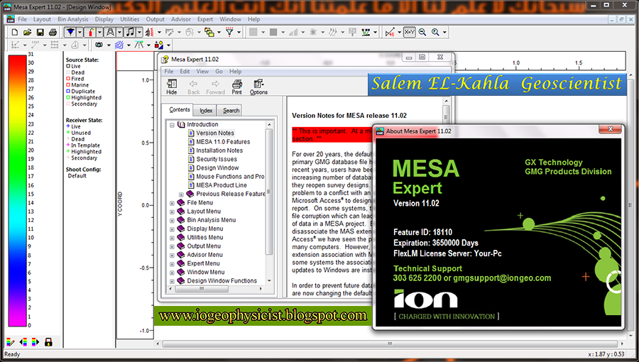
ION's MESA software addresses those needs for both land and marine projects by optimizing survey design and planning to deliver the right information to help make those critical decisions.
MESA is the industry standard for designing seismic acquisition surveys. The development team works in partnership continuously with its customers to add functionality, improve performance, and enhance the user experience.
MESA's principal functionality includes:
Survey design and subsurface coverage analysis for 3D/3C and VSP surveys.
Geologic modeling, ray tracing, and illumination analysis.
Chronological project tracking and crew production statistics.
MESA Suite of Software Packages
MESA Expert: the ultimate 3D survey design tool with geologic modeling and enhanced ray tracing.
MESA Professional: provides a complete set of tools for 3D, full-wave and VSP design and analysis.
MESA Field: ideal for advanced 3D acquisition planning capability with a basic analysis package.
How Install MESA Expert v11.02
1- Setup program without restarting the system. 2- Open "Crack" folder and Copy "flexlm" folder to "C:\". 3- Copy "lmgr11.dll" to "C:/gmg/Mesa 11.02". 4- Run the program from "mesa.exe". 5- Enjoy.
Landmark's integrated software and services help the upstream oil and gas industry turn critical information into useful knowledge. With this knowledge, our clients can see further, deeper, more accurately and more comprehensively than ever. So they can make better decisions with less risk than ever.
GeoGraphix
Discover power and deliver efficiency. GeoGraphix offers a software portfolio that streamlines geoscience, engineering and decision support, including risk analysis and production economics on the Windows® platform.
How Install Landmark GeoGraphixDiscoveryv5000.0.2.0
1- Setup the Program. 2- Choose "I need to install a license" then press on next. 3- Detect the location of the license file "license_34f.dat" then press on next. 4- Enjoy.